GEON (Geospatial Experience-Oriented Notation) is an open data format designed to make geospatial information legible — not just to mapping software, but to people and AI systems that need to reason about place.
Standard geospatial formats like GeoJSON or WKT are precise, efficient, and deeply capable for rendering maps and running geometry calculations. But they are fundamentally coordinate-first: a polygon is a list of numbers; a point is a latitude and longitude. The richer meanings attached to those coordinates — what a place feels like, who uses it, when, and why — exist nowhere in the file.
GEON addresses this by treating places as semantic objects. A GEON document describes not just where something is, but what it is, how it functions, how it relates to its surroundings, and how people experience it. It is a lightweight text format with a clean, readable structure — close enough to YAML to feel familiar, flexible enough to describe anything from a Victorian market square to a real-time transport interchange.
The Problem with Coordinates
Consider how urban design typically works: a planner opens a GIS dataset, sees polygons and attributes, and must mentally reconstruct what a place actually is before any meaningful analysis can begin. Now consider asking an AI assistant to do the same. A coordinate array conveys nothing about whether a street is vibrant or desolate, safe or hostile, historically significant or newly constructed. Even with attributes attached, standard formats offer a flat “bag of properties” — no hierarchy, no relationships, no sense of what any of it means to the people who use the space.
This isn’t a failing of GeoJSON or WKT — those formats were built for geometry, and they excel at it. But the growing use of LLMs in spatial workflows has exposed a gap: we lack formats optimised for reasoning about place rather than rendering it.
GEON is directly inspired by TOON (Token-Oriented Object Notation), a format that demonstrated how representing objects in terms of their purpose and behavior — rather than just their physical properties — unlocks dramatically more capable AI reasoning. GEON applies this insight to the spatial domain. The semantic fields draw on decades of research in environmental psychology, space syntax, and urban design theory — making concepts like enclosure, permeability, and social diversity machine-readable for the first time.
Format Design
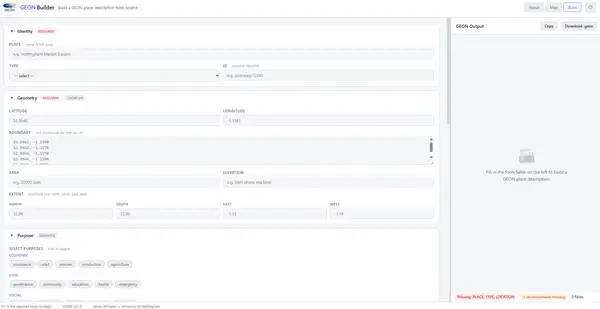
A GEON document is a UTF-8 text file describing one or more PLACE entities. The minimal valid document needs only three fields:
PLACE: Nottingham Market Square
TYPE: public_space
LOCATION: 52.9548, -1.1581
From this starting point, documents can be enriched with semantic, relational, temporal, and provenance information:
PLACE: Nottingham Market Square
TYPE: public_space
LOCATION: 52.9548, -1.1581
PURPOSE:
  - civic gathering
  - events and festivals
  - informal commerce
EXPERIENCE:
  openness: high
  activity_density: variable
  noise_level: moderate
  sense_of_safety: high (daytime), moderate (evening)
ADJACENCIES:
  - Old Market Square tram stop (50m north)
  - Council House (immediate west)
TEMPORAL:
  weekday_footfall: 2000-3000 people/hour
  weekend_events: 2-3 per month
The format reads like a document, not a data file. A planner, architect, historian, or community researcher can produce GEON without any programming knowledge. An LLM can parse and reason over it without any special tooling.
GEON organises its fields into five logical groups — Identity, Geometry, Semantic, Relational, and Temporal. The EXPERIENCE field is perhaps the most distinctive, encoding phenomenological qualities that are almost entirely absent from standard geospatial data:
EXPERIENCE:
  openness: high
  enclosure: medium
  noise_level: loud
  visual_complexity: very_high
  sense_of_safety: high (daytime), moderate (nighttime)
  social_diversity: very_high
Places contain other places, and relate to them in ways that matter. GEON makes both explicit through CONTAINS, ADJACENCIES, VIEWSHEDS, and PART_OF fields — building a graph of places connected by meaning, not just proximity.
Why GEON Works for LLMs
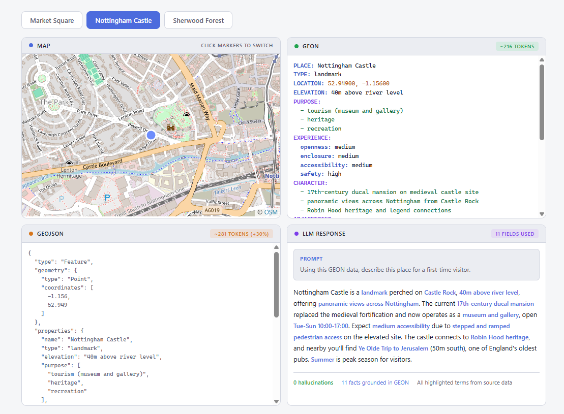
Large language models are, at their core, trained on text. They understand sentences, paragraphs, structured documents. What they struggle with is dense numeric data with no semantic scaffolding — a polygon defined by 47 coordinate pairs conveys nothing that the model can reason over in human terms.
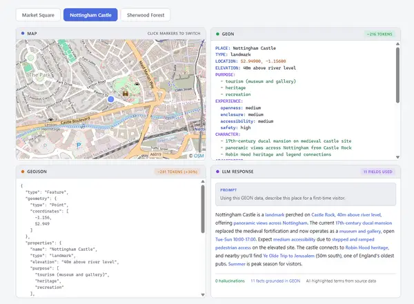
GEON optimises for what might be called semantic density: the amount of reasoning-relevant information per token. Every field name is meaningful; every value is interpretable; relationships are named and explicit. This lets an LLM answer questions like:
“What public spaces within 500m of New Street Station are suitable for outdoor dining?”
…by actually reasoning over the EXPERIENCE, PURPOSE, and ADJACENCIES fields of nearby GEON entities, rather than performing geometric computation it was never designed for.
The format also enables generative spatial reasoning: given a GEON description of an underutilised street, an LLM can propose design interventions and express them back in GEON — creating a feedback loop between analysis and generation.
Implementations
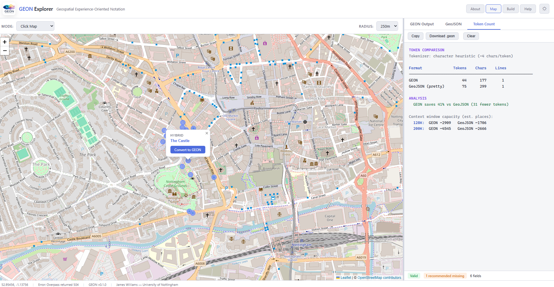
GEON is a format specification, not a software product — but the spec ships with three official library implementations to make it immediately usable:
geon-py(Python) — data science, scripting, and pipeline integrationgeon-rs(Rust) — high-performance parsing, CLIs, and system integrationgeon-js(JavaScript / TypeScript) — web applications and Node.js services
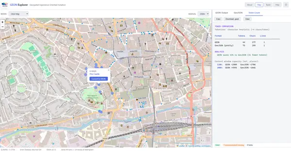
All three support the full GEON 0.1.0 specification: parsing, programmatic generation, schema validation, and bidirectional GeoJSON conversion. GeoJSON interoperability is a first-class concern — GEON can be generated from GeoJSON (enriching coordinates with semantic metadata) and serialized back to GeoJSON for compatibility with existing GIS tooling.
The Ecosystem
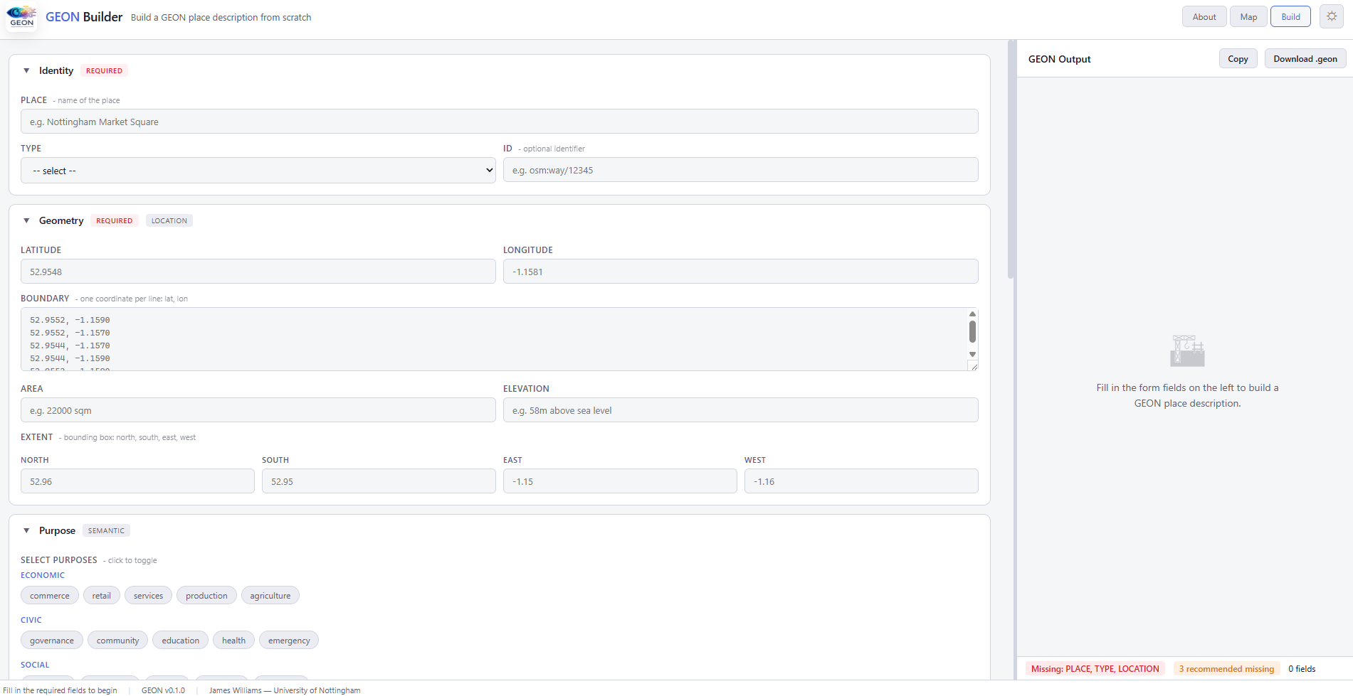
The core format and libraries are the foundation; the broader GEON ecosystem extends their reach:
- VS Code Extension (
geon-vscode) — syntax highlighting, field autocompletion, and live validation for.geonfiles - MCP Server (planned) — a Model Context Protocol server that exposes GEON repositories to LLMs natively, allowing AI agents to search, read, and query spatial knowledge without custom integration code
- CLI Tool (planned) — a unified
geoncommand for validating files, formatting documents, and converting between GEON and GeoJSON on the command line - QGIS Plugin (planned) — direct rendering of
.geonfiles in QGIS by converting to GeoJSON on the fly - Web Validator (planned) — a browser-based drag-and-drop validator and structure preview for non-technical contributors
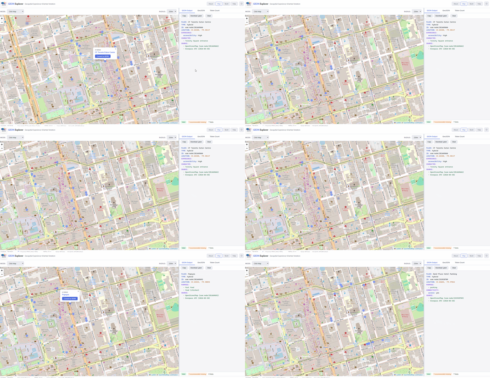
Comparison with Related Formats
GEON is not trying to replace GeoJSON or CityGML. The relationships are complementary:
vs. GeoJSON — GeoJSON handles geometry and rendering; GEON handles meaning and reasoning. GeoJSON’s flat properties bag offers low semantic richness and no experiential encoding. GEON’s structured fields and controlled vocabulary provide the semantic layer that GeoJSON deliberately omits. They convert to and from each other.
vs. CityGML — CityGML excels at architectural precision and simulation at high geometric fidelity. GEON operates at a higher level of abstraction, prioritising semantic and experiential richness in a format that is orders of magnitude simpler to produce and parse.

vs. OpenStreetMap tags — OSM’s tag system is an invaluable source for GEON — OSM tags can populate PURPOSE and CHARACTER fields. But OSM tags are flat key-value pairs with no hierarchy, no controlled experiential vocabulary, and no relational structure. GEON is a curated, contextual layer built on top of sources like OSM.
Use Cases
Agentic urban analysis — AI agents tasked with urban research or planning support need to traverse spatial knowledge efficiently. A GEON repository of a city’s public spaces, street network, and key buildings gives an agent the semantic context to answer high-level questions, identify patterns, and generate structured recommendations without specialised GIS tools.
Generative spatial modelling — Given a GEON description of an existing place, an LLM can generate design intervention scenarios expressed back in GEON — predicting how proposed changes to street layout, land use, or programming might alter the experiential profile of a space.
Spatial knowledge graphs — GEON’s relational fields make it natural to build knowledge graphs where nodes are places and edges carry semantic meaning, supporting network analyses of how places connect and influence one another beyond geometric proximity.
Multi-source data integration — GEON’s SOURCE and CONFIDENCE fields provide a principled way to document the provenance of heterogeneous urban datasets — geometry from Ordnance Survey, land use from local authority open data, footfall from transport APIs, experiential qualities from field observation — enabling transparent, reproducible integration.

Limitations and Future Directions
Current limitations — Experiential fields are inherently observer-dependent; a single field observation in winter may not represent a place’s full character. The format’s strength — human-curated richness — is also a production bottleneck at urban scale. Community conventions around field usage are still forming.
Future directions include: LLM-assisted automated enrichment from raw GeoJSON plus satellite imagery; temporal GEON for encoding how places have evolved historically; 3D GEON with vertical profile fields for multi-storey buildings; dynamic GEON with real-time API-connected source fields; and an empirical evaluation framework measuring the downstream impact of GEON representation on LLM spatial reasoning benchmarks.
The longer-term ambition is to move GEON from a research specification toward an open community standard — with formal governance for vocabulary extensions, domain-specific field proposals, and versioning.
Research Significance
The world is not made of coordinates. It is made of places — with character, purpose, history, and social life. The tools we use to represent space should reflect this. As spatial AI matures and LLMs become increasingly embedded in urban planning, design, and research workflows, the formats we use to represent geographic information will matter more, not less.
GEON is an initial proposal — versioned, open, and designed for community evolution. It demonstrates that format design choices have significant consequences for what AI systems can do with spatial data: a contribution as much to AI as to GIS.
Specification licence: CC BY 4.0 · Code licence: MIT · Version: 0.1.0 (February 2026)