Pedestrian flows in urban spaces emerge from chained activities as opposed to isolated trips. People stitch together sequences of places for errands, work, leisure, or emergency. The corridors we observe in cities are co-produced by clusters of amenities, street structures, and locations—not single origin-destination pairs alone.
PlaceAgents treats urban pedestrian movement as a series of linked flows, intermediate stops, and the itinerary logic that connects them, supporting simulation design in urban analytics and planning.

The Itinerary Perspective
Most pedestrian models focus on origin-destination pairs, but this misses how people actually move through cities. A morning routine might involve:
- Walking to a coffee shop
- Stopping at the bank
- Browsing a bookshop
- Having lunch at a restaurant
- Returning home
Each leg of this journey creates flow on the network. PlaceAgents captures this itinerary-centred behaviour, revealing patterns that OD approaches miss.
Three Core Principles
The framework is built on three foundational principles:
1. Access to Open Data
PlaceAgents uses exclusively open data sources. Pedestrian networks and Points of Interest are sourced from OpenStreetMap via OSMnx, enabling reproducible research without proprietary data dependencies.
2. Explicit Agent Assumptions
Rather than hiding behavioural complexity in black-box models, PlaceAgents makes all agent assumptions transparent. Researchers can inspect and modify how agents choose destinations, plan routes, and move through the network.
3. Auditability of Outputs
Every simulation produces an auditable event log. Each agent movement, arrival, and routing decision is recorded, enabling detailed analysis and verification of results.
Framework Architecture
The PlaceAgents pipeline separates concerns into modular, inspectable stages:
Processing
A routable pedestrian network is extracted from OpenStreetMap with a walking filter including footways, paths, pedestrian roads, steps, and shared surfaces. POIs are extracted and snapped to their nearest network nodes.
Spatial Aggregation
Network and place context is summarised into H3 hexagonal grid cells. This enables:
- POI density analysis
- Network coverage metrics
- Distributed load reporting proportional to segment overlap
The H3 grid provides a uniform representation that supports multi-resolution analysis—from neighbourhood scale to city-wide patterns.
Agent Simulation
Agents represent pedestrians executing short itineraries of place visits. Each agent maintains:
- Current position on the network
- Ordered target list of places to visit
- Planned path using A* routing
- State: planning, moving, arrived, stuck, or finished
Routes are computed using length-weighted A* shortest-path cost, providing interpretable and transparent navigation logic.
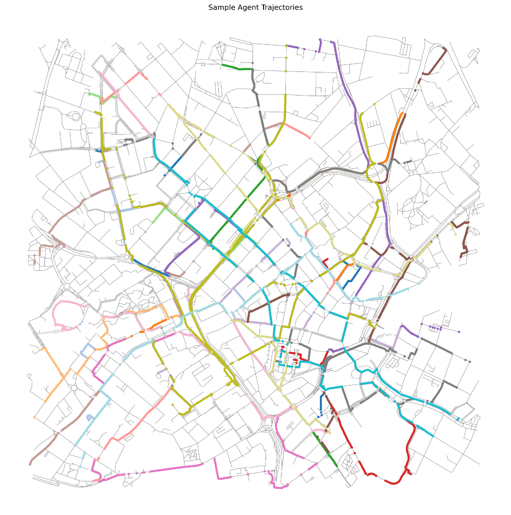
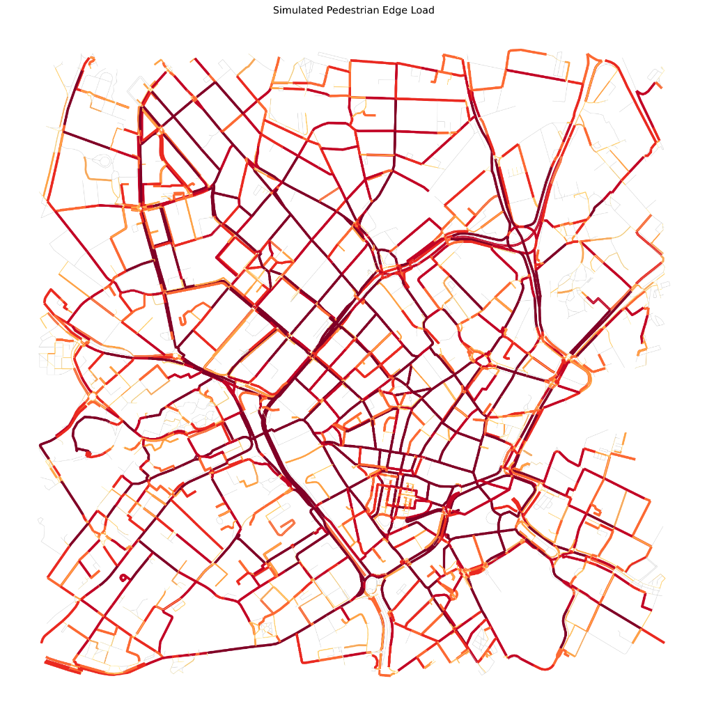
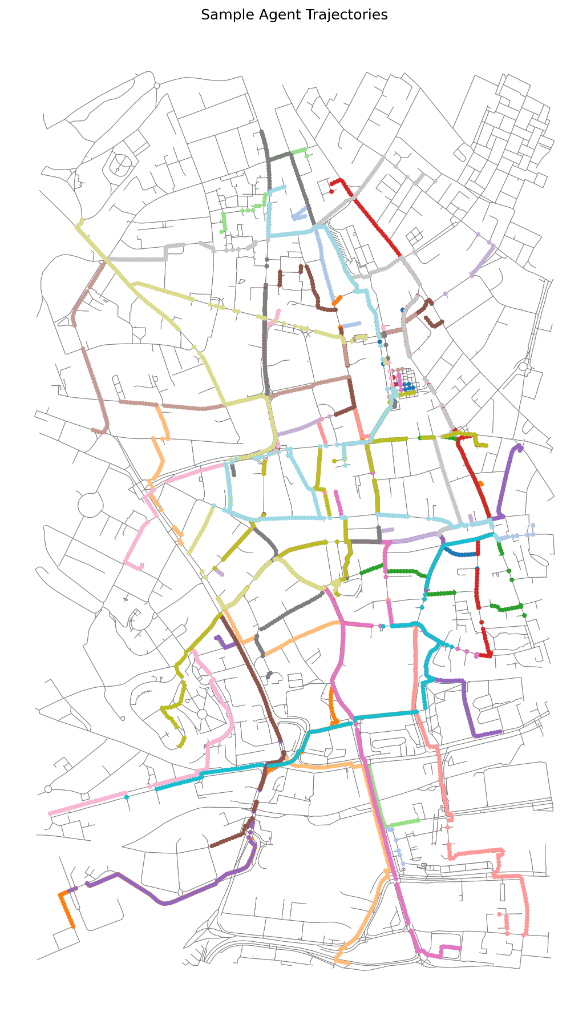
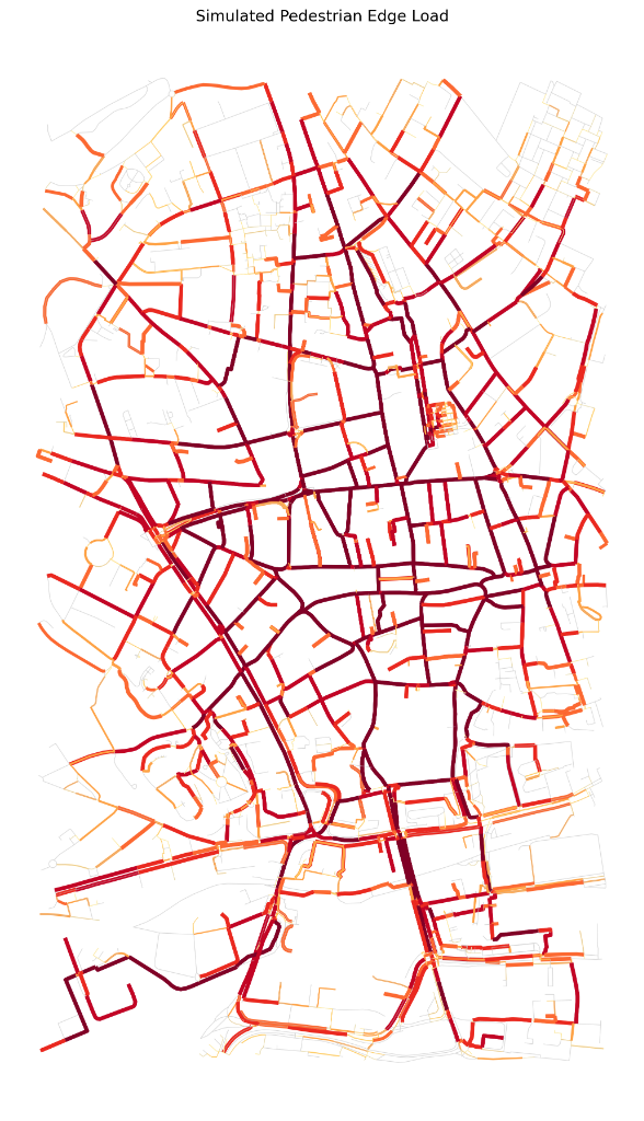
Case Studies: Nottingham and Birmingham
Two UK city centres were simulated with identical parameters (1,000 agents, 360 ticks, resolution 9):
| Metric | Nottingham | Birmingham |
|---|---|---|
| Network Nodes | 2,460 | 3,297 |
| Network Edges | 6,446 | 8,918 |
| Points of Interest | 1,317 | 1,858 |
| H3 Hexagons | 26 | 54 |
| Median Edge Length | 19.5m | 24.5m |
| Median Leg Length | 631m | 1,243m |
| Gini Coefficient | 0.82 | 0.77 |
Key Findings
Nottingham showed highly concentrated corridors through the core street grid, with lighter use on backstreets. The high Gini coefficient (0.82) indicates a small set of dominant segments carrying most pedestrian flow.
Birmingham demonstrated comparatively longer legs and lower concentration, reflecting the larger network and wider amenity spread. Plausibility checks showed strong correlation between simulated load and node betweenness (Spearman ρ = 0.87).
Interactive Viewer
PlaceAgents includes a web-based interactive viewer for exploring simulation results:
- Edge load visualisation showing pedestrian flow intensity
- Place markers indicating Points of Interest
- Animated agent positions during simulation playback
- Trajectory traces following individual agents
- Playback controls for scrubbing through time
The viewer illustrates how itineraries concentrate flow along a small set of corridors while backstreets remain lightly used.
Platial Implications
The PlaceAgents approach offers two key impacts:
Flow-based place identification: The platial lens supports identification of high-throughput place-based locations imported from OpenStreetMap, enabling flows and platial clusters to be discovered.
Event-based analysis: Agent event logs, edge demand, and H3 summaries can inform place identification where traditional GPS traces aren’t available—encouraging work on identifying meaningful places to individuals.
The framework treats the city as linked places rather than abstract space, chaining activities and local semantics that origin-destination approaches miss.
Limitations
The current implementation adopts simplified behavioural assumptions:
- Agents are walkers only (no transit or cycling)
- Short multi-stop sequences only
- Length-based routing (no scenic or safety preferences)
- Limited by OpenStreetMap data completeness (opening hours, capacity)
Future work will integrate richer narratives into itineraries and explore exposure accounting (air quality, noise, safety).
Future Extensions
Planned developments include:
- Exposure layering: Integrating air pollution, noise, and safety data into H3 grids
- User cohorts: Distinct agent types (commuters, students, tourists) with different schedules and preferences
- Larger scale simulation: Performance optimisations for city-wide modelling
- Cross-city comparisons: Systematic analysis across multiple urban contexts
Open Source
PlaceAgents is available as open-source software for research and development:
Repository: github.com/jwilliamsresearch/PlaceAgents
Data used is OpenStreetMap® open data, licensed under the Open Data Commons Open Database License (ODbL) by the OpenStreetMap Foundation. This research was conducted at the Centre for Disruptive Era Studies, Birmingham Newman University.