← All topics
GIS
GIS
13 posts
28 Apr 2026  25 Apr 2026
  22 Apr 2026
  15 Apr 2026
  15 Mar 2026
  19 Feb 2026
  12 Feb 2026
  07 Feb 2026
  05 Feb 2026
  03 Oct 2025
 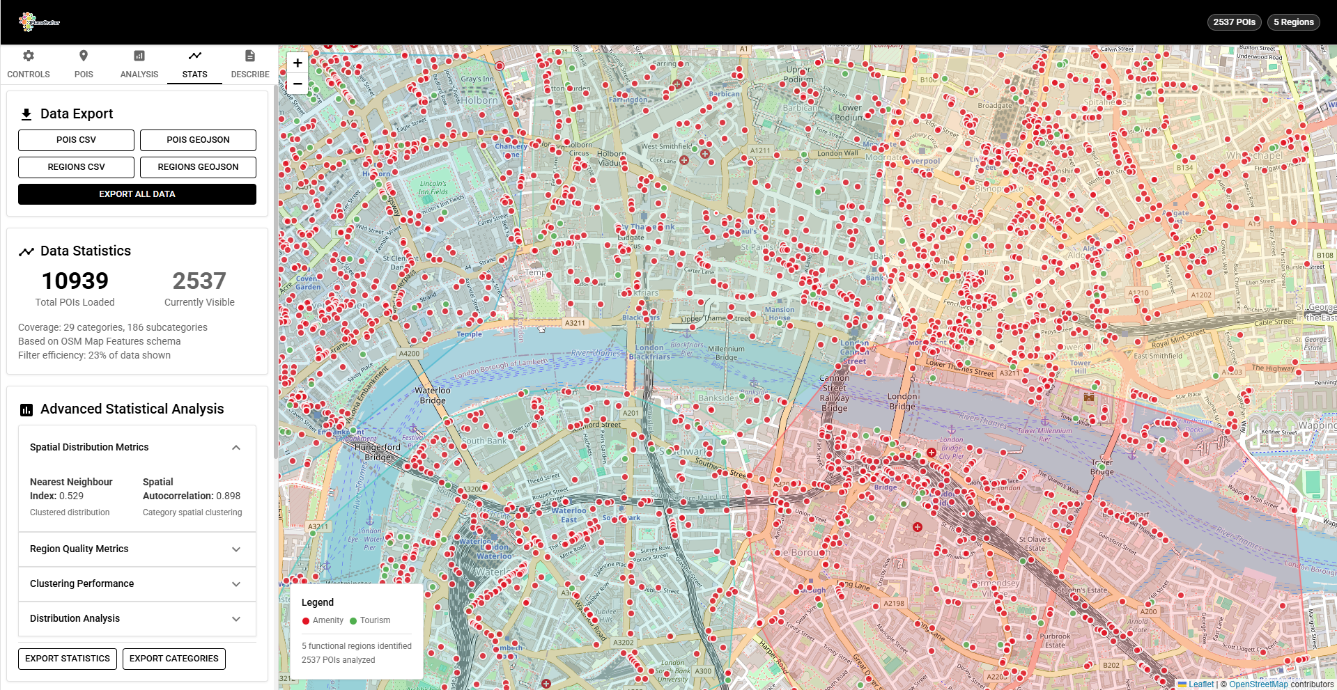 02 Sept 2025
  16 Aug 2025
 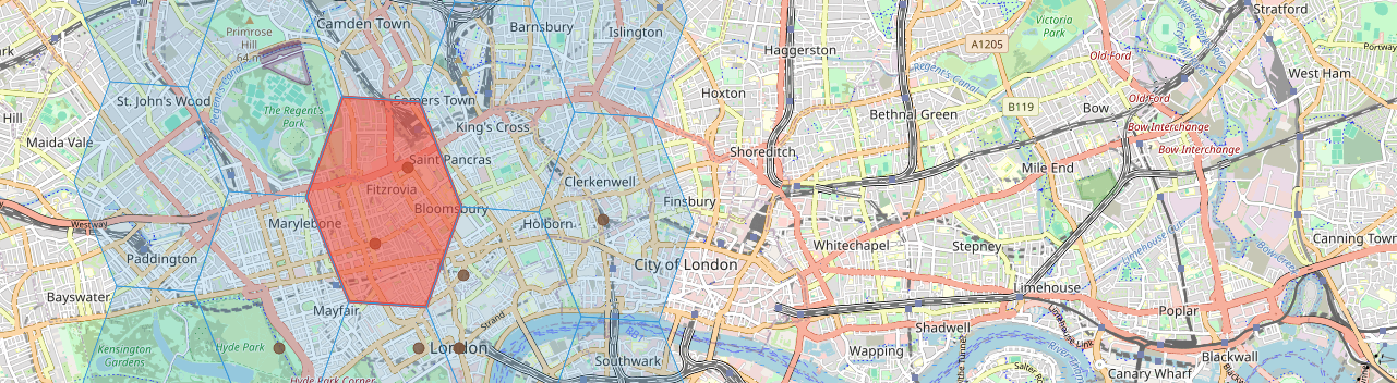 03 Aug 2025
H3 Hierarchy and Compaction: Multi-Resolution Spatial Analysis
Learn how H3's hierarchical structure enables multi-resolution analysis, how parent-child relationships work across resolution levels, and how the compactCells and uncompactCells functions reduce redundant spatial representations. Includes interactive browser demos and practical code examples.
25 Apr 2026 H3 Catchment Analysis: Modelling Service Areas with Hexagonal Grids
Learn how to use H3's gridDisk, gridRing, and gridDistance functions to model service areas, accessibility zones, and multi-source catchment overlap. Includes interactive browser-based demos with step-by-step code.
22 Apr 2026 H3 Density Mapping: Visualising Urban Point Data as Hexagonal Heatmaps
Learn how to aggregate point data into hexagonal density maps using H3 and Leaflet. This tutorial covers spatial binning, choropleth colouring, power-scaled colour ramps, and interactive multi-resolution analysis — all running in the browser.
15 Apr 2026 What Do Large Language Models Know About Place?
A reflective piece on how large language models represent place: the difference between spatial and platial knowledge, what LLMs do well (cultural associations, character, narrative), what they get wrong (boundaries, recency, under-represented places), and how to build applications that use this capability honestly.
15 Mar 2026 DuckDB as an In-Process Spatial Analytics Engine
A practical guide to using DuckDB's spatial extension for geospatial analysis. Covers installing the extension, running ST_Within and ST_Distance queries over large Parquet datasets, integrating with Python and the broader data ecosystem, and comparing the approach to traditional spatial database setups.
19 Feb 2026 Cloud-Native Geospatial: GeoParquet, COGs, and STAC
An introduction to the cloud-native geospatial stack: GeoParquet for vector data, Cloud Optimized GeoTIFFs (COGs) for raster data, and the SpatioTemporal Asset Catalog (STAC) specification for discovery. Covers practical Python examples using rio-cogeo, pystac-client, and geopandas with GeoParquet.
12 Feb 2026 Spatial ETL Pipelines with GeoPandas and Shapely
A practical guide to building spatial ETL (extract, transform, load) pipelines using GeoPandas and Shapely. Covers reading and writing spatial formats, geometry validation and repair, coordinate reference system management, spatial joins, and outputting clean data to PostGIS or GeoParquet.
07 Feb 2026 Chora: The First Python Library for Place-Based Computing
Introducing Chora, the first Python library to model the human experience of place. Built on rigorous theory from GIScience, cognitive geography, and social physics, Chora provides tools for processing GPS traces, detecting routines, mapping emotions, and understanding places as lived experiences rather than coordinate pairs.
05 Feb 2026 Spatial Narrative: A Rust Library for Spatiotemporal Event Analysis
Spatial Narrative is a high-performance Rust library for modelling, indexing, and analysing events that unfold across geographic space and chronological time. Built for researchers, digital humanists, and data scientists, it provides spatial indexing, movement analysis, named entity recognition, and multi-format I/O.
03 Oct 2025 PlaceCrafter: Curating Urban Functional Regions through Platial Clustering
PlaceCrafter is a web-based platform that enables researchers to identify meaningful urban regions through clustering OpenStreetMap Points of Interest. Built with React, Leaflet, and D3.js, it provides interactive clustering, statistical validation, and platial visualisation of how cities are actually used.
02 Sept 2025 Platial Atlas: Mapping How People Experience Places
Discover how the Platial Atlas project proposes capturing and representing places as they are lived and perceived by communities, using the PlaceCrafter framework to move beyond conventional geographic boundaries.
16 Aug 2025 Getting Started with H3: The Hexagonal Grid System for Spatial Analysis
This hands-on tutorial introduces H3, Uber's open-source hexagonal grid system that's transforming spatial analysis. Learn why hexagons outperform traditional grids, set up H3 in JavaScript, and build interactive mapping applications with step-by-step code examples.
03 Aug 2025 Why 'Placing Code' Matters
This manifesto-style post introduces the concept of 'placing code' - software development that respects geography, culture, and context. Drawing from research in Geographic Information Science and platial information systems, it argues for technology that serves human spatial relationships rather than replacing them.