Research Summary and Evaluation Framework
Executive Overview
WalkGrid represents a novel computational approach to personalizing urban walking experiences through multivariate environmental analysis and user-centered preference modeling. Unlike traditional route planning systems that optimize solely for efficiency metrics (shortest distance, fastest time), WalkGrid explicitly models the qualitative, experiential dimensions of walking environments to support route curation based on what makes walking meaningful—greenspace, cultural interest, safety, air quality, and dozens of other environmental characteristics.
This research platform addresses a critical gap in active travel and urban design: the systematic integration of environmental preferences into navigable route planning. By combining hexagonal spatial indexing (Uber H3), large-scale geospatial databases (PostGIS), similarity-based search algorithms, and routing infrastructure (OSRM), WalkGrid enables users to discover walks that match their subjective criteria for engagement, aesthetics, and experiential quality.
Research Context and Motivation
Walking represents far more than a mode of transport—it is a fundamental human activity with profound implications for physical health, mental wellbeing, social cohesion, environmental sustainability, and place attachment. Urban planners and public health practitioners increasingly recognize that designing walkable cities requires attention not only to accessibility and safety but also to the experiential qualities that make walking pleasant, engaging, and meaningful.
Traditional routing systems, from Google Maps to dedicated walking apps, prioritize algorithmic efficiency: they compute the shortest path or fastest route between origin and destination. While useful for navigation, these tools neglect the environmental context that shapes walking experiences. A 2-kilometer walk through a busy arterial road differs dramatically from a 2-kilometer walk through parks and quiet residential streets—yet conventional routing treats them as equivalent.
WalkGrid emerged from the recognition that computational tools could do better. The platform operationalizes the concept of environmental similarity: the idea that places with similar environmental characteristics—tree coverage, proximity to water, density of cultural sites, air quality—offer comparable experiential qualities. By modeling these characteristics systematically and enabling users to weight them according to personal preferences, WalkGrid transforms route planning from an optimization problem into a curation process.
System Architecture and Technical Innovation
Hexagonal Spatial Indexing
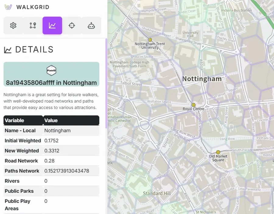
WalkGrid employs Uber’s H3 hierarchical hexagonal indexing system at resolution 10 (hexagons approximately 150 meters across) as the fundamental spatial unit. This design choice provides several advantages:
- Uniform spatial representation: Unlike administrative boundaries or irregular polygons, hexagons offer consistent geometry and comparable area across the study region
- Hierarchical aggregation: H3 supports multi-resolution analysis, enabling future extensions to neighborhood or city-scale patterns
- Efficient spatial operations: H3’s indexing structure accelerates nearest-neighbor queries and spatial joins
- Reproducibility: H3 is an open standard with implementations across programming languages, facilitating replication and extension
Each hexagon in the WalkGrid database represents a distinct place characterized by a comprehensive environmental feature vector.
Multivariate Environmental Feature Engineering
The core innovation of WalkGrid lies in its 51-dimensional environmental feature space. Each hexagon is scored across diverse indicators spanning:
- Transport infrastructure: road density, path density, river density
- Greenspace typology: public parks, play spaces, golf courses, sports facilities, religious grounds, allotments
- Land use composition: water bodies, tree coverage, wetlands, crops, built area, bare ground, grassland
- Terrain and safety: elevation variance, recent crime rates (1-month, 6-month, 1-year), CCTV coverage
- Urban amenities: street lighting, council-maintained trees, population density
- Cultural heritage: listed buildings, historical plaques
- Air quality: PM10 particulate matter, NO2 nitrogen dioxide, with temporal snapshots and percentiles
- Points of interest: food and drink, cafés, pubs, attractions, recreational facilities, tourism sites, transport nodes, retail
All features are min-max normalized to [0, 1] to ensure comparability across disparate measurement scales. This normalization is critical for distance-based similarity metrics and enables interpretable weighting.
The feature engineering pipeline integrates data from Ordnance Survey, local government open data, air quality monitoring networks, crime statistics, and OpenStreetMap. The system is designed for extensibility: additional features—noise levels, thermal comfort, social media sentiment—can be incorporated without architectural changes.
Weighted Similarity Algorithms
WalkGrid implements three distance-based similarity metrics to support diverse user preferences and analytical objectives:
-
Cosine similarity: Measures the angle between feature vectors, emphasizing correlation structure rather than magnitude. Robust when users care about relative proportions (e.g., “more trees than roads”) rather than absolute values.
-
Euclidean distance: Standard L2 norm capturing absolute differences across all dimensions. Sensitive to large disparities in individual features. Converted to similarity via exponential transformation.
-
Manhattan distance: L1 norm summing absolute differences. Less sensitive to outliers than Euclidean, useful for sparse feature spaces.
Users can apply custom weights to emphasize specific features. Weights are normalized and applied multiplicatively to feature vectors before distance computation. This approach translates latent user preferences into explicit, interpretable computational operations.
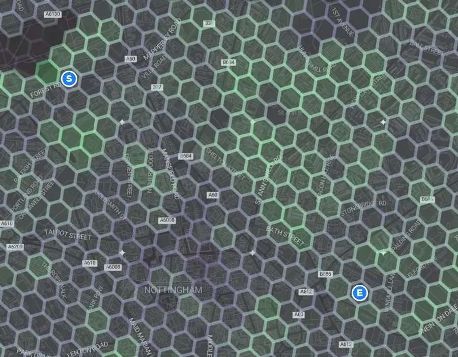
Spatially-Constrained Search with PostGIS
A key challenge in similarity-based route curation is balancing semantic similarity (environmental matching) with geographic feasibility (walkable distance). WalkGrid addresses this through PostGIS spatial filters:
- The system constrains similarity search to hexagons within a user-specified radius (measured in H3 ring distances)
- PostGIS
ST_DWithinperforms geodesic distance filtering, ensuring results are both environmentally similar and geographically accessible - Results are ranked by similarity score and presented as interactive map overlays
This hybrid semantic-spatial filter distinguishes WalkGrid from pure recommendation systems (which ignore geography) and pure routing systems (which ignore environmental context).
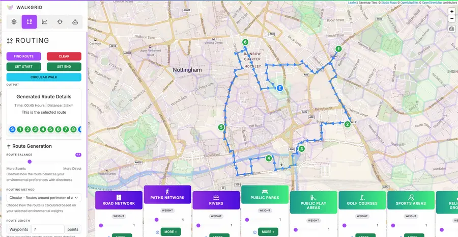
Integration with OSRM Routing Engine
While similarity analysis identifies desirable hexagons, users need navigable routes through them. WalkGrid integrates the Open Source Routing Machine (OSRM) to construct walking paths:
- Users select a reference hexagon (current location or desired starting point)
- Similarity search identifies environmentally-matched hexagons within walking range
- Users select target hexagons from the similarity overlay
- OSRM computes pedestrian routes through the selected sequence
- Routes are displayed with environmental overlays, enabling iterative refinement
OSRM operates on OpenStreetMap pedestrian network data, ensuring routes follow actual sidewalks and paths. The integration supports waypoint-based routing, allowing users to construct multi-segment walks through diverse environments.
Version Evolution and Evaluation Strategy
WalkGrid V1: Interface-Based Selection and Think-Aloud Study
The initial version of WalkGrid (V1) presented users with a checkbox-and-slider interface for selecting and weighting environmental features. Users could:
- Toggle features on/off (e.g., select “parks,” “cafés,” “quiet streets”)
- Adjust importance sliders (0–10 scale)
- Specify whether to seek more (+) or less (−) of each feature
This interface was evaluated through a think-aloud study. The study yielded valuable insights:
Positive findings:
- Users appreciated high-level, abstract selections (e.g., “green and quiet” rather than granular feature manipulation)
- Participants demonstrated clear conceptual models of desirable walking environments
- The similarity-based matching concept resonated with users’ mental models of place
Interface challenges:
- The checkbox-and-slider interface proved cognitively demanding
- Many users struggled with the abstraction gap between their experiential desires and the system’s feature-level inputs
- Decision fatigue led to shallow engagement
The V1 evaluation was effective in confirming the validity of the underlying similarity model and revealing strong user preference for intuitive, high-level interaction. However, it also highlighted that the interface constituted a critical barrier to system usability and adoption.
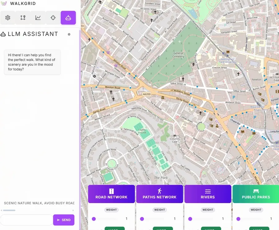
WalkGrid V2: LLM-Mediated Preference Elicitation
Building on V1 findings, WalkGrid V2 introduces a conversational interface powered by large language models (LLMs) to bridge the abstraction gap. Instead of manipulating sliders, users describe their ideal walk in natural language:
“I want a quiet walk with lots of greenery"
"Show me routes with historical sites and cafés, avoiding busy roads”
The LLM assistant (implemented using Google’s Gemini API) performs intent recognition and preference translation:
- Parsing user intent: Identifies environmental characteristics mentioned in user queries
- Mapping to features: Maps terms to database feature columns
- Weight inference: Infers relative importance from linguistic cues
- Iterative refinement: Users can provide feedback, and the LLM adjusts weights accordingly
The V2 interface includes suggestion chips, conversational history, and visualization of selected features to ensure transparency.
V2 Evaluation: User Engagement with LLM-Based Selection
The evaluation of WalkGrid V2 focuses on how users interact with the LLM to express environmental preferences. Specific research questions include:
- Interaction patterns: How many conversational turns do users require? What linguistic strategies do they employ?
- Preference expressiveness: Does the LLM successfully capture nuanced, multi-dimensional preferences?
- Trust and transparency: Do users understand how their natural language inputs map to feature weights?
- Engagement and exploration: Does the conversational interface encourage deeper exploration of the feature space?
- Outcome quality: Do routes generated via LLM-mediated selection better match user preferences?
Evaluation methods include interaction logging, usability surveys (NASA-TLX, SUS), preference validation, comparative studies against V1, and qualitative interviews.
Research Contributions and Broader Implications
Methodological Contributions
-
Operationalization of environmental similarity: WalkGrid provides a reproducible, extensible framework for quantifying place similarity across multivariate environmental indicators.
-
Bridging semantic and spatial constraints: The combination of similarity-based search with geographic filtering addresses a persistent challenge in location-based systems.
-
Human-AI collaboration in preference modeling: V2 explores how LLMs can mediate between high-level user intent and low-level system parameters.
Practical Impacts
- Active travel promotion: Designing walking interventions tailored to individual preferences
- Urban design: Identifying under-served areas and targeting interventions
- Tourism: Supporting discovery of novel routes aligned with visitor interests
Scientific Opportunities
- Behavioral science: Field experiments comparing engagement and health outcomes
- Environmental psychology: Investigating how specific environmental features influence affective responses
- Equity analysis: Mapping access to desirable walking environments across socioeconomic strata
Limitations and Future Directions
Current Limitations
- Data quality: Dependence on underlying datasets; varying temporal validity
- Perceptual limits: Difficulty quantifying subjective qualities like “quietness” or “beauty”
- Accessibility: Currently lacks detailed accessibility data (curb cuts, stairs)
- Scalability: Currently limited to single region; requires pipeline adaptation for new cities
Future Research Directions
- Participatory sensing: Integrate user-contributed measurements and ratings
- Real-time data: Incorporate weather, noise, and air quality feeds
- Longitudinal evaluation: Track long-term engagement and behavioral change
- Multi-objective optimization: Balance multiple criteria (e.g., greenspace vs. distance)
- Equity-aware design: Safeguards against reinforcing spatial inequalities
Conclusion
WalkGrid advances the science and practice of designing engaging walking experiences by integrating rigorous spatial analysis, interpretable preference modeling, and user-centered interface design. The transition from V1’s interface-based selection to V2’s LLM-mediated interaction represents a fundamental shift in how users express environmental preferences—from manual parameter manipulation to conversational curation.
Beyond its immediate application to walking route curation, WalkGrid demonstrates broader principles for designing computational tools that honor the experiential, subjective dimensions of human-environment interaction.